Sector F, Noida
+91 9891555001 / 9311475175
info@mytechpro.co.in

Agricultural Survey

Drone-based agricultural survey and GIS mapping solutions for crop monitoring, field mapping, vegetation analysis, irrigation planning and smarter agricultural management.

Request Survey
AGRICULTURAL SURVEY & MAPPING

Smarter Agriculture Through Drone & GIS Technology

MyTechPro provides professional agricultural survey solutions using drone-based aerial imagery, GIS mapping, spatial analysis and digital agricultural datasets.

Our solutions help visualize agricultural land, monitor crop conditions, analyze vegetation, identify field variations and support irrigation, land management and agricultural planning.

✔ Drone-Based Agricultural Survey
✔ High-Resolution Crop & Field Imagery
✔ Agricultural Land Mapping
✔ Crop Health & Vegetation Monitoring
✔ GIS-Based Field Mapping
✔ Irrigation & Drainage Analysis
✔ NDVI & Vegetation Analysis
✔ Digital Agricultural Reports
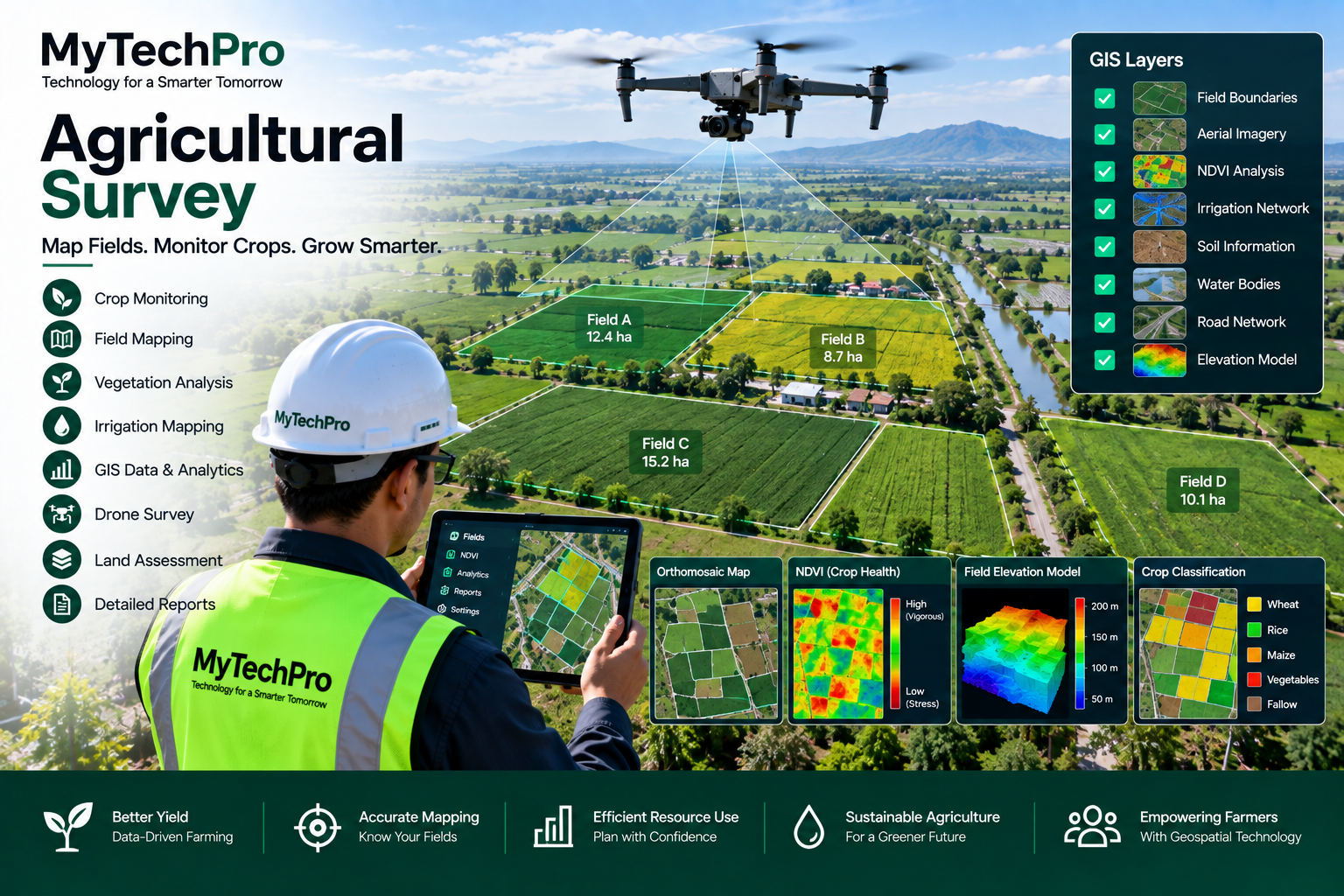
Agricultural Survey and Drone Mapping
OUR AGRICULTURAL SURVEY SERVICES

Complete Digital Agriculture Survey Solutions

Capture, map and analyze agricultural land using modern drone, GIS and geospatial technologies.

Drone Crop Survey

Capture high-resolution aerial imagery of agricultural fields for crop monitoring, field documentation and vegetation assessment.

Agricultural Land Mapping

Create detailed digital maps of farmland, field boundaries, access roads, water bodies and other agricultural features.

Crop Health Monitoring

Monitor crop conditions and identify visible field variations using aerial imagery and vegetation analysis techniques.

Vegetation Analysis

Analyze vegetation patterns and field conditions using multispectral or other suitable aerial datasets.

Irrigation Mapping

Map irrigation networks, drainage patterns, water bodies and field elevations to support agricultural water management.

GIS Agricultural Mapping

Integrate agricultural survey information with GIS platforms for spatial analysis, field management and digital reporting.

Drone Agricultural Survey
DRONE AGRICULTURAL MONITORING

See the Entire Field from a Single Digital View

Drone surveys provide a detailed aerial view of agricultural land, allowing large field areas to be captured efficiently and documented digitally.

Repeated surveys can create a time-series record that helps compare field conditions across different dates and agricultural stages.

✔ High-Resolution Aerial Photography
✔ Field-Wise Image Capture
✔ Crop Growth Monitoring
✔ Time-Series Field Comparison
✔ Problem Area Identification
✔ Digital Survey Documentation
CROP & VEGETATION ANALYSIS

Convert Field Imagery into Agricultural Insights

Spatial and vegetation datasets can help identify field variations and support targeted agricultural monitoring.

Vegetation Index

Generate vegetation index maps such as NDVI when suitable multispectral imagery is available.

Field Variation

Visualize variations in crop or vegetation conditions across different areas of a field.

Crop Mapping

Create spatial maps to visualize crop areas, field boundaries and agricultural features.

Trend Monitoring

Compare survey results over time to support agricultural monitoring and field management.

AGRICULTURAL GIS

Build a Digital GIS Map of Your Agricultural Land

Agricultural GIS mapping brings together field boundaries, crop information, aerial imagery, irrigation infrastructure, soil information and other spatial datasets in a single digital environment.

This enables agricultural organizations, land managers and project teams to visualize field information and perform location-based analysis.

✔ Farm & Field Boundary Mapping
✔ Crop-Wise GIS Layers
✔ Irrigation Network Mapping
✔ Water Body & Drainage Mapping
✔ Aerial Imagery Integration
✔ Spatial Database Management
✔ Interactive GIS Visualization
✔ Digital Agricultural Reports
Agricultural GIS Mapping
APPLICATION AREAS

Agricultural Survey Applications

Farm & Field Management

Map individual fields and maintain digital records for agricultural land and field management.

Crop Monitoring

Monitor crop development and identify spatial variations across agricultural fields.

Irrigation Planning

Map irrigation systems, drainage routes, water bodies and terrain conditions to support planning.

Terrain & Elevation

Analyze field elevation, slopes, contours and terrain characteristics using survey and mapping data.

Land Development

Support agricultural land development and planning with accurate spatial information.

Agricultural Data Management

Organize field, crop, imagery and spatial information into structured digital datasets.

DIGITAL SURVEY OUTPUTS

Agricultural Data Ready for Analysis

Field Maps

Detailed digital maps showing agricultural fields, boundaries and important site features.

Orthomosaic

High-resolution georeferenced aerial imagery for field visualization and spatial reference.

GIS Layers

Structured GIS layers for fields, crops, irrigation, drainage and other agricultural assets.

Survey Reports

Digital reports containing maps, imagery, observations and relevant survey information.

OUR WORKFLOW

From Field Survey to Digital Agricultural Insights

01. Plan

Define the agricultural area, survey objectives, required imagery and mapping outputs.

02. Survey

Conduct planned drone flights and capture aerial imagery of the agricultural area.

03. Process

Process imagery and spatial datasets to generate maps, models and analytical outputs.

04. Analyze

Review field information, vegetation patterns, terrain and other relevant spatial characteristics.

KEY BENEFITS

Smarter Agricultural Monitoring

Better Field Visibility

Get a detailed aerial view of agricultural land and visualize field conditions from a broader perspective.

Accurate Spatial Mapping

Create digital maps and GIS layers that organize agricultural information geographically.

Data-Driven Monitoring

Use imagery and spatial information to support structured field monitoring and analysis.

Periodic Monitoring

Repeat surveys to create a time-series record of agricultural field conditions.

Centralized Data

Maintain field maps, imagery and spatial information in organized digital datasets.

Digital Reporting

Generate clear maps, visual outputs and survey reports for agricultural planning and documentation.

Need an Agricultural Survey for Your Land?

Get professional drone surveying, agricultural mapping, GIS analysis and digital field monitoring solutions from MyTechPro.

Request an Agricultural Survey